
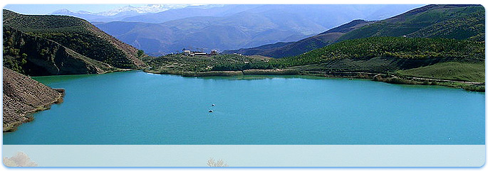
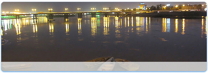
 Mazandaran - Chaloos - Valasht Lake


Iran is located in southwest Asia and borders the Gulf of Oman, Persian Gulf, and Caspian Sea. Its mountains have helped to shape both the political and the economic history of the country for several centuries. The mountains enclose several broad basins, or plateaus, on which major agricultural and urban settlements are located. Until the 20th century, when major highways and railroads were constructed through the mountains to connect the population centers, these basins tended to be relatively isolated from one another.
Typically, one major town dominated each basin, and there were complex economic relationships between the town and the hundreds of villages that surrounded it. In the higher elevations of the mountains rimming the basins, tribally organized groups practiced transhumance, moving with their herds of sheep and goats between traditionally established summer and winter pastures. There are no major river systems in the country, and historically transportation was by means of caravans that followed routes traversing gaps and passes in the mountains. The mountains also impeded easy access to the Persian Gulf and the Caspian Sea.
With an area of 1,648,000 square kilometers (636,000 sq mi), Iran ranks eighteenth in size among the countries of the world.
Iran shares its northern borders with three post-Soviet states: Armenia, Azerbaijan, and Turkmenistan. These borders extend for more than 2,000 kilometers (1,200 mi), including nearly 650 kilometers (400 mi) of water along the southern shore of the Caspian Sea. Iran's western borders are with Turkey in the north and Iraq in the south, terminating at the Shatt al-Arab, which Iranians call the Arvand Rud.
The Persian Gulf and Gulf of Oman littorals form the entire 1,770 kilometers (1,100 mi) southern border. To the east lie Afghanistan on the north and Pakistan on the south. Iran's diagonal distance from Azerbaijan in the northwest to Sistan and Baluchestan Province in the southeast is approximately 2,333 kilometers (1,450 mi).
- Topography
The topography of Iran consists of rugged, mountainous rims surrounding high interior basins. The main mountain chain is the Zagros Mountains, a series of parallel ridges interspersed with plains that bisect the country from northwest to southeast.
Many peaks in the Zagros exceed 3,000 meters (9,843 ft) above sea level, and in the south-central region of the country there are at least five peaks that are over 4,000 meters (13,123 ft).
As the Zagros continue into southeastern Iran, the average elevation of the peaks declines dramatically to under 1,500 meters (4,921 ft).
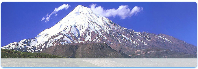
Rimming the Caspian Sea littoral is another chain of mountains, the narrow but high Alborz Mountains. Volcanic Mount Damavand, 5,610 meters (18,406 ft), located in the center of the Alborz, is not only the country's highest peak but also the highest mountain on the Eurasian landmass west of the Hindu Kush.
The center of Iran consists of several closed basins that collectively are referred to as the Central Plateau. The average elevation of this plateau is about 900 meters (2,953 ft), but several of the mountains that tower over the plateau exceed 3,000 meters (9,843 ft). The eastern part of the plateau is covered by two salt deserts, the Dasht-e Kavir (Great Salt Desert) and the Dasht-e Lut. Except for some scattered oases, these deserts are uninhabited.
Iran has only two expanses of lowlands: the Khuzestan Plain in the southwest and the Caspian Sea coastal plain in the north. The former is a roughly triangular-shaped extension of the Mesopotamia plain and averages about 160 kilometers (99 mi) in width. It extends for about 120 kilometers (75 mi) inland, barely rising a few meters above sea level, and then meets abruptly with the first foothills of the Zagros. Much of the Khuzestan plain is covered with marshes.
The Caspian plain is both longer and narrower. It extends for some 640 kilometers (400 mi) along the Caspian shore, but its widest point is less than 50 kilometers (31 mi), while at some places less than 2 kilometers (1.2 mi) separate the shore from the Alborz foothills. The Persian Gulf coast south of Khuzestan and the Gulf of Oman coast have no real plains because the Zagros in these areas come right down to the shore.
There are no major rivers in the country. Of the small rivers and streams, the only one that is navigable is the 830 kilometers (520 mi)-long Karun, which shallow-draft boats can negotiate from Khorramshahr to Ahvaz, a distance of about 180 kilometers (110 mi). Other major rivers include the Kharkeh, spanning 700 kilometers (430 mi) and joining the Tigris; and the Zayandeh River, which is 300 kilometers (190 mi) long. Several other permanent rivers and streams also drain into the Persian Gulf, while a number of small rivers that originate in the northwestern Zagros or Alborz drain into the Caspian Sea.
On the Central Plateau, numerous rivers—most of which have dry beds for the greater part of the year—form from snow melting in the mountains during the spring and flow through permanent channels, draining eventually into salt lakes that also tend to dry up during the summer months. There is a permanent salt lake, Lake Urmia (the traditional name, also cited as Lake Urmiyeh, to which it has reverted after being called Lake Rezaiyeh under Mohammad Reza Shah), in the northwest, whose brine content is too high to support fish or most other forms of aquatic life. There are also several connected salt lakes along the Iran-Afghanistan border in the province of Baluchestan va Sistan.
- Flora and fauna
More than one-tenth of the country is forested. The most extensive growths are found on the mountain slopes rising from the Caspian Sea, with stands of oak, ash, elm, cypress, and other valuable trees. On the plateau proper, areas of scrub oak appear on the best-watered mountain slopes, and villagers cultivate orchards and grow the plane tree, poplar, willow, walnut, beech, maple, and mulberry. Wild plants and shrubs spring from the barren land in the spring and afford pasturage, but the summer sun burns them away. According to FAO reports, the major types of forests that exist in Iran and their respective areas are:
1. Caspian forests of the northern districts – 19,000 km2 (7,300 sq mi)
2. Limestone mountainous forests in the northeastern districts (Juniper forests – 13,000 km2 (5,000 sq mi)
3. Pistachio forests in the eastern, southern and southeastern districts – 26,000 km2 (10,000 sq mi)
4. Oak forests in the central and western districts – 35,000 km2 (14,000 sq mi)
5. Shrubs of the Kavir (desert) districts in the central and northeastern part of the country – 10,000 km2 (3,900 sq mi)
6. Sub-tropical forests of the southern coast, like the Hara forests – 5,000 km2 (1,900 sq mi)
More than 2,000 plant species are grown in Iran. The land covered by Iran's natural flora is four times that of the Europe’s.
Map of biotopes of Iran
Forest steppe
Forests and woodlands
Semi-desert
Desert lowlands
Steppe
Salted alluvial marshes
Wildlife of Iran is diverse and composed of several animal species including bears, gazelles, wild pigs, wolves, jackals, panthers, Eurasian lynx, and foxes. Domestic animals include sheep, goats, cattle, horses, water buffalo, donkeys, and camels. The pheasant, partridge, stork, eagles and falcon are also native to Iran.
As of 2001, 20 of Iran's mammal species and 14 bird species are endangered. Among them are the Baluchistan bear (Ursus thibetanus gedrosianus), a subspecies of Asian Black Bear, Persian fallow deer, Siberian Crane, hawksbill turtle, green turtle, Oxus cobra, Latifi's viper, dugong and dolphins. The Asiatic Cheetah is a critically endangered species which extinct elsewhere and now can only be found in Iran.
Iran lost all its Asiatic Lions and Caspian Tigers by the earlier part of the 20th century. The Syrian wild ass has become extinct. Bears in the mountains, wild sheep and goats, gazelles, wild asses, wild pigs, panthers, and foxes abound. Domestic animals include sheep, goats, cattle, horses, water buffalo, donkeys, and camels. The pheasant, partridge, stork, and falcon are native to Iran.
The Persian leopard is said to be the largest of all the subspecies of leopards in the world. The main range of this species in Iran closely overlaps with that of Bezoar Ibex. Hence, it is found throughout Alborz and Zagros mountain ranges, as well as smaller ranges within the Iranian plateau. Leopard population is very sparse, due to loss of habitat, loss of natural prey, and population fragmentation. Apart from Bezoar Ibex, wild sheep, boar, deer (either Maral red deer or roe deer), and domestic animals constitute leopards' diet in Iran.
- Resources and land use
Natural resources: petroleum, natural gas, coal, chromium, copper, iron ore, lead, manganese, zinc, sulfur
Arable land: 10%
Permanent crops: 1%
Permanent pastures: 27%
Forests and woodlands: 13%
Other: 49% (1998 est.)
Irrigated land: 94,000 km2 (36,000 sq mi) (1993 est.)